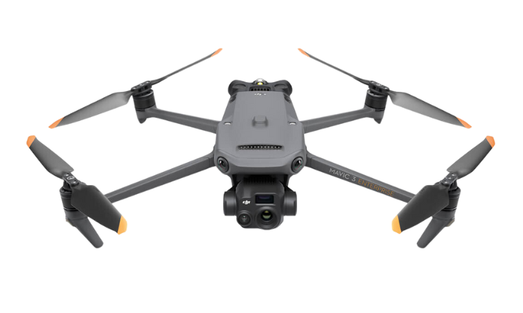
Compact and Portable
Foldable for easy storage
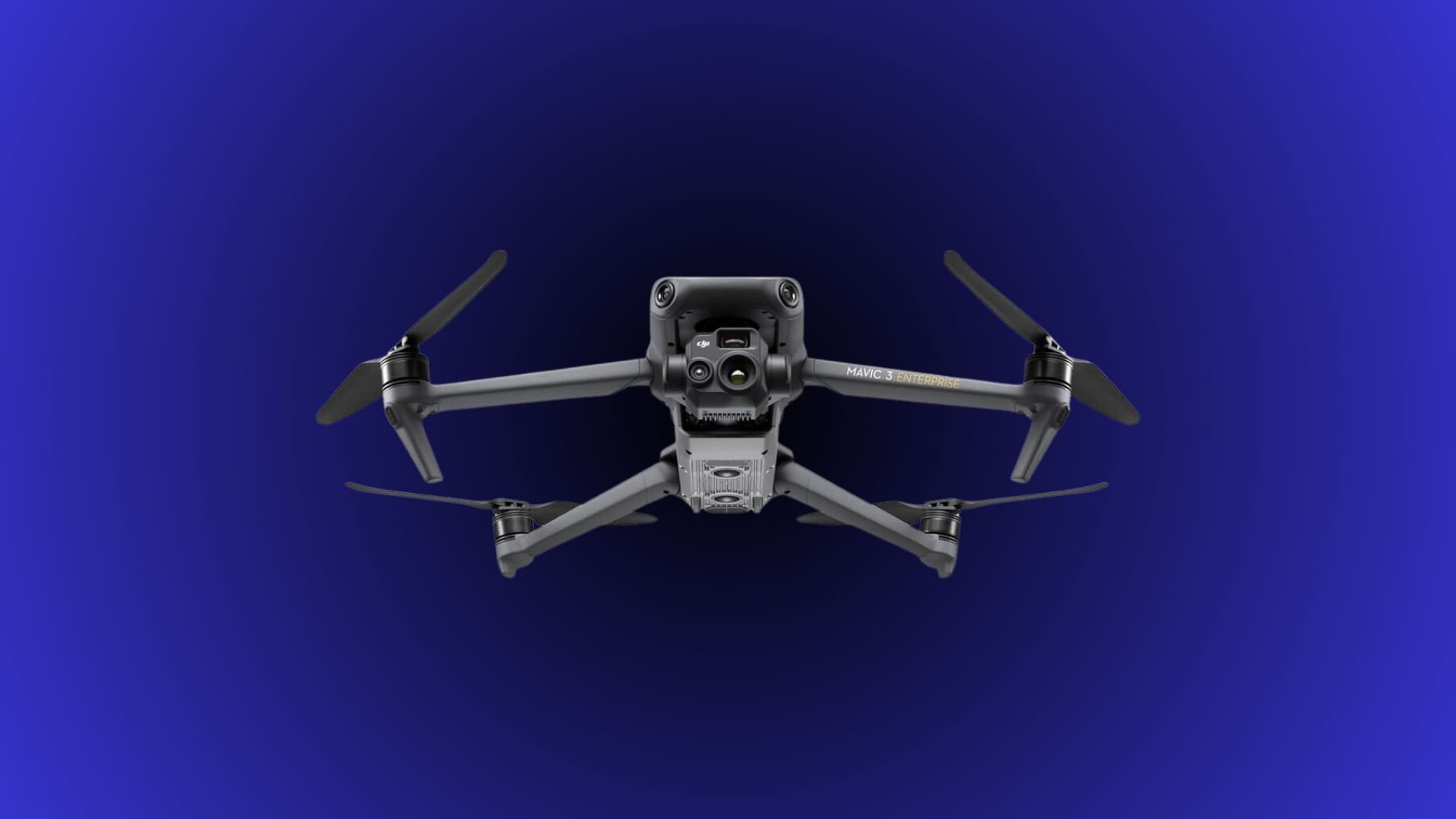
Multispectral Camera
Mavic 3T is equipped with a 12MP Zoom Camera, supporting up to 56× Max Hybrid Zoom to see essential details from afar.
Termal Camera
Mavic 3T's thermal camera has 640 × 512 resolution and supports point and area temperature measurement.
Precise Positioning
Centimeter-level RTK positioning Synchronization at microsecond level
Safe and Stable
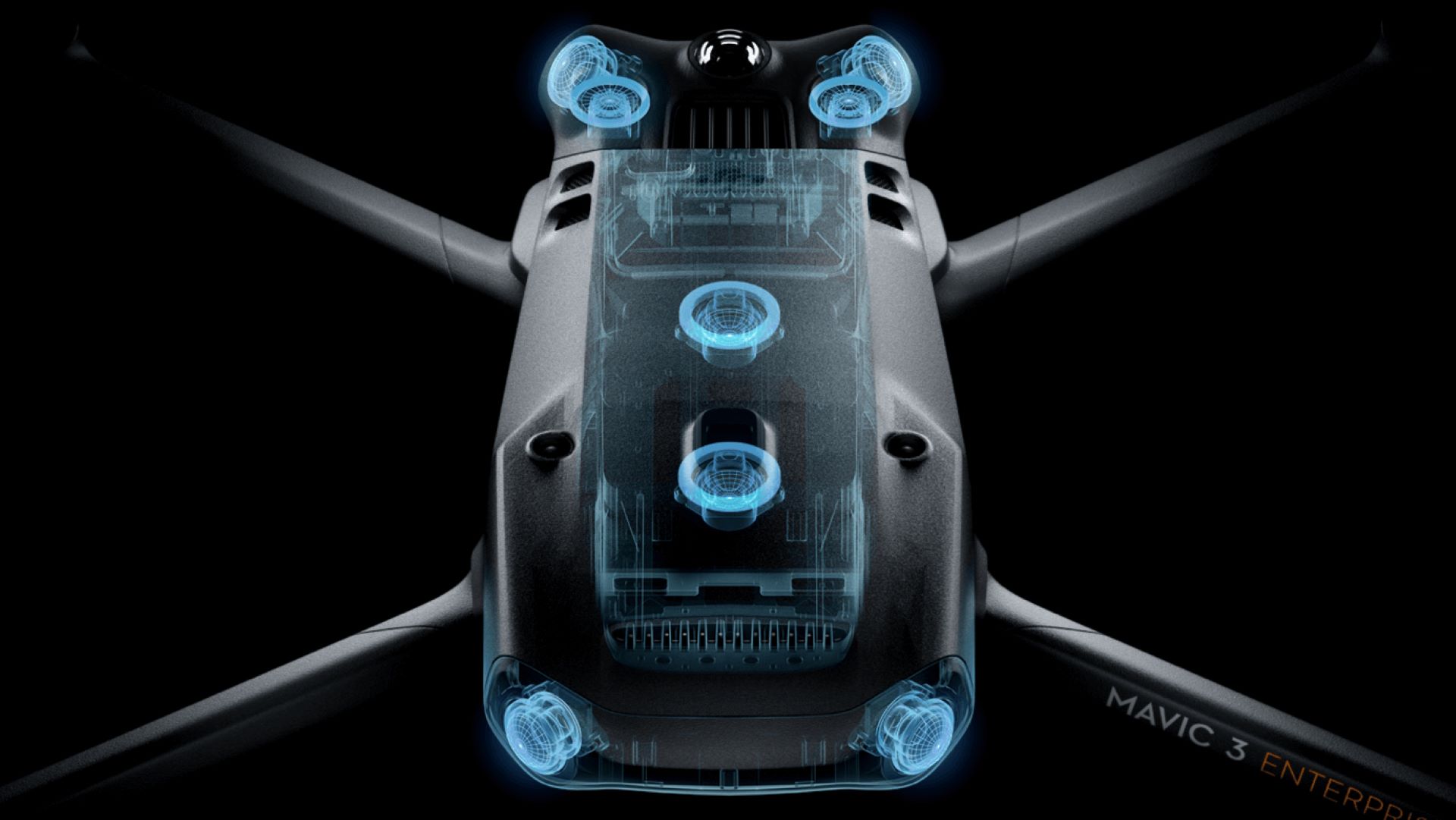
Omnidirectional binocular vision system, supplemented with an infrared sensor at the bottom of the aircraft.
Max Flight Time
45-Minute Maximum Flight Time
Fly SAFE
Enhancing Flight Safety with Omnidirectional Sensing.
Safety and Accuracy are key to the Mavic 3T.
The DJI Mavic 30T is equipped with wide-angle lenses on all sides, providing comprehensive obstacle avoidance without any blind spots. Its omnidirectional sensing capabilities allow for a proactive approach to obstacle detection and avoidance, ensuring a safe and reliable flight experience. Additionally, the proximity alarms and braking distance can be adjusted according to specific mission requirements, providing flexibility and customization to adapt to varying operational needs. With its advanced obstacle avoidance features, the Matrice 30T offers enhanced safety and precise control, allowing professionals to focus on their missions with confidence.
Advanced RTH
Accurate and automatic route planning
With its advanced Return-to-Home (RTH) feature, the Mavic 3T intelligently calculates and navigates the most efficient route back home, conserving power, saving time, and eliminating unnecessary complications.
Live Terrain Tracking
Automatic intelligent Terrain Tracking
The Mavic 3T excels at mapping areas with diverse elevations by autonomously adjusting its altitude, eliminating the need for external elevation data. This remarkable capability is achieved through the Mavic 3T's omnidirectional sensing, enabling precise and seamless mapping even in environments with varying terrain.
Automatic Rerouting
Fly without worry with Mavic 3T
Experience worry-free flying with the Mavic 3T's APAS 5.0, which ensures automatic rerouting around obstacles, providing you with peace of mind throughout your flight.
Intelligent Oblique Capture
Capture smartly during flight
Enhance the efficiency of your oblique photography missions with the Mavic 3T drone's Smart Oblique Capture feature. During flight, the gimbal effortlessly rotates in three directions—front, middle, and back—to capture photos from the required angles for high-precision 3D modeling.
Optimized Batteries
Maximizing Flight Endurance with Optimized Batteries
With impressive 45-minute flight durations, the Mavic 3T allows you to extend your coverage and survey vast areas of up to 2 square kilometers in a single mission, increasing efficiency and productivity.
Multispectral + RGB Imaging System
Highly Integrated Imaging System
Newly upgraded imaging system with one 20MP RGB camera and four 5MP multispectral cameras (green, red, red edge, and near infrared). Enables applications such as high-precision aerial surveying, crop growth monitoring, and natural resource surveys.
DJI MAVIC 3T Packages
Everything you need to be airborne today!
DJI Mavic 3T Specifications
Aircraft Specs
| Parameter | DJI Mavic 3T |
|---|---|
| Weight (with propellers, without accessories) [1] | 2.03 lb |
| Max Takeoff Weight | 2.31 lb |
| Dimensions |
Folded (without propellers): 8.7×3.8×3.6 in (L×W×H) Unfolded (without propellers): 13.7×11.1×4.2 in (L×W×H) |
| Diagonal Distance | 14.96 in |
| Max Ascent Speed | 19.69 ft/s (Sport Mode) |
| Max Descent Speed | 19.69 ft/s (Sport Mode) |
| Max Flight Speed (at sea level, no wind) | 49.21 ft/s (Normal Mode) Forward: 68.9 ft/s, Side: 65.6 ft/s, Backward: 62.34 ft/s (Sport Mode) [2] |
| Max Wind Speed Resistance | 26.8 ft/s [3] |
| Max Take-off Altitude Above Sea Level | 19,685 ft (without payload) |
| Max Flight Time (no wind) | 43 minutes [4] |
| Max Hover Time (no wind) | 37 minutes |
| Max Flight Distance | 12.37 miles |
| Max Tilt Angle | 30° (Normal Mode) 35° (Sport Mode) |
| Max Angular Velocity | 200°/s |
| GNSS | GPS+Galileo+BeiDou+GLONASS (GLONASS is supported only when the RTK module is enabled) |
| Hovering Accuracy |
Vertical: ±0.3 ft (with Vision System); ±1.6 ft (with
GNSS); ±0.3 ft (with D-RTK) Horizontal: ±1.0 ft (with Vision System); ±1.6 ft (with HD Positioning System); ±0.3 ft (with RTK) |
| Operating Temperature Range | 14° to 104° F |
| Internal Storage | N/A |
| Motor Model | 2008 |
| Propeller Model | 9453F Propellers for Enterprise |
| Beacon | Built into the aircraft |
Wide Camera Specs
| Specification | DJI Mavic 3T |
|---|---|
| Sensor | 1/2-inch CMOS Effective pixels: 48 MP |
| Lens |
FOV: 84° Format Equivalent: 24 mm Aperture: f/2.8 Focus: 3.28 feet to ∞ |
| ISO Range | 100-25600 |
| Shutter Speed | Electronic Shutter: 8-1/8000 s |
| Max Image Size | 8000×6000 pixels |
| Still Photography Modes |
Single: 12 MP/48 MP Timed: 12 MP/48 MP JPEG: 2/3/5/7/10/15/20/30/60 seconds* Panorama: 12 MP (raw image); 100 MP (stitched image) Smart Low-light Shooting: 12 MP |
| Video Resolution |
H.264 4K: 3840×2160 pixels at 30 fps FHD: 1920×1080 pixels at 30 fps |
| Bitrate |
4K: 85 Mbps FHD: 30 Mbps |
| Supported File Formats | exFAT |
| Photo Format | JPEG |
| Video Format | MP4 (MPEG-4 AVC/H.264) |
Thermal Camera Specs
| Thermal Imager | Uncooled VOx Microbolometer |
|---|---|
| Pixel Pitch | 0.00048 inches |
| Frame Rate | 30 Hz |
| Lens |
DFOV: 61° Format Equivalent: 1.57 inches Aperture: f/1.0 Focus: 16.4 feet to ∞ |
| Sensitivity | ≤50 mk@F1.1 |
| Temperature Measurement Method | Spot Meter, Area Measurement |
| Temperature Measurement Range |
-4° to 302° F (High Gain Mode) 32° to 932° F (Low Gain Mode) |
| Palette | White Hot/Black Hot/Tint/Iron Red/Hot Iron/Arctic/Medical/Fulgurite/Rainbow 1/Rainbow 2 |
| Photo Format |
JPEG (8-bit) R-JPEG (16-bit) |
| Video Resolution | 640×512 pixels at 30 fps |
| Bitrate | 6 Mbps |
| Video Format | MP4 (MPEG-4 AVC/H.264) |
| Still Photography Modes |
DJI Mavic 3T: Single: 640×512 pixels Timed: 640×512 pixels JPEG: 2/3/5/7/10/15/20/30/60 seconds |
| Digital Zoom | 28x |
| Infrared Wavelength | 8-14 μm |
| Infrared Temperature Measurement Accuracy | ±2° C or ±2% (using the larger value) |
Sensing Specs
| Direction | Measurement Range | Detection Range | Effective Sensing Speed | FOV |
|---|---|---|---|---|
| Forward | 1.6-65.6 ft | 1.6-656.2 ft | Flight Speed ≤49.2 ft/s | Horizontal 90°, Vertical 103° |
| Backward | 1.6-52.5 ft | N/A | Flight Speed ≤39.4 ft/s | Horizontal 90°, Vertical 103° |
| Lateral | 1.6-82 ft | N/A | Flight Speed ≤49.2 ft/s | Horizontal 90°, Vertical 85° |
| Upward | 0.7-32.8 ft | N/A | Flight Speed ≤19.7 ft/s | Front and Back 100°, Left and Right 90° |
| Downward | 0.9-59.1 ft | N/A | Flight Speed ≤19.7 ft/s | Front and Back 130°, Left and Right 160° |
Note: The operating environment for the sensing system requires a surface with a clear pattern and adequate lighting (lux >15) for forward, backward, lateral, and upward sensing. For downward sensing, it requires a diffuse reflective surface with diffuse reflectivity >20% (e.g., walls, trees, people) and adequate lighting (lux >15).
Speaker Specs
| Capacity | 5000 mAh |
|---|---|
| Standard Voltage | 15.4 V |
| Max Charging Voltage | 17.6 V |
| Type | LiPo 4S |
| Chemical System | LiCoO2 |
| Energy | 77 Wh |
| Weight | 0.74 lb |
| Charging Temperature | 41° to 104° F |
Charger Specs
| Input | 100-240 V (AC Power), 50-60 Hz, 2.5 A |
|---|---|
| Output Power | 100 W |
| Output | Max. 100 W (total) |
| Output (When both ports are used) | Max. 82 W per port |
| Dynamic Power Allocation | The charger will allocate the output power dynamically between the two ports based on the load power. |
Battery Specs
| Capacity | 5000 mAh |
|---|---|
| Standard Voltage | 15.4 V |
| Max Charging Voltage | 17.6 V |
| Type | LiPo 4S |
| Chemical System | LiCoO2 |
| Energy | 77 Wh |
| Weight | 0.74 lb |
| Charging Temperature | 41° to 104° F |
Midwest Air
Proudly servicing Ohio and the Midwest regions
