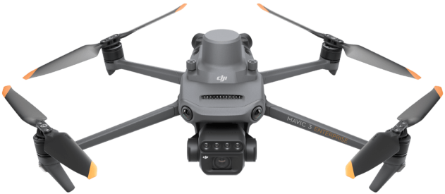
Compact and Portable
Foldable for easy storage
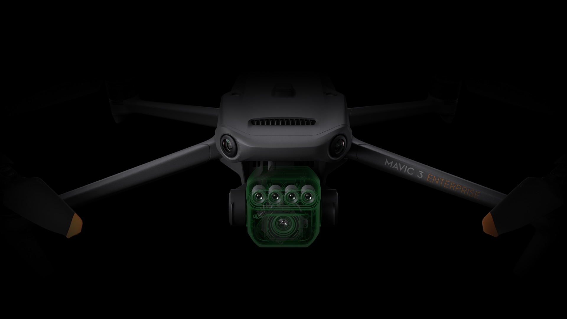
Multispectral Camera
4 × 5 MP G/R/RE/NIR Highly imaging
RGB Camera
20 MP 4/3 CMOS, mechanical shutter
Precise Positioning
Centimeter-level RTK positioning Synchronization at microsecond level
Safe and Stable
Omnidirectional obstacle avoidance 15 km transmission distance
Efficient Aerial Surveying
Up to 200 hectares per flight
See the INVISIBLE
Effective aerial surveying needs to see the invisible.
That's why Mavic 3 Multispectral has two forms of sight.
It combines an RGB camera with a multispectral camera to scan and analyze crop growth with total clarity. Agricultural production management requires precision and data, and Mavic 3M delivers both.
RTK Module
Accurate images that capture every pixel
Mavic 3M with RTK module for centimeter-level positioning. Flight control, the camera, and the RTK module sync in microseconds to accurately capture the location of each camera's imaging center. This enables Mavic 3M to do high-precision aerial surveying without using ground control points.
Field Scouting
Automatic intelligent field scouting
Find abnormalities, such as emergence deficiencies, weed pressure, and crop lodging in a timely manner. Conduct intelligent analyses, such as cotton seedling identification and rice production testing, using AI identification for real-time sharing of crop growth information, guidance of agronomic activities, and easy management of 70 hectares of farmland by one person.
Ultra-long Battery Life
Efficient and reliable battery life
- 43 Minutes Cruise Time
- 200 hectare Complete Mapping
- 100W Batter Charging Hub
- 200 hectare Complete Mapping
Obstacle Avoidance
Detect obstacles in all directions
Features multiple wide-FOV vision sensors that accurately detect obstacles in all directions for omnidirectional obstacle avoidance. The terrain-follow aerial surveying can be easily performed in steep-slope landscapes.
Stable Signal
Smooth and stable image transmission
The O3 transmission integrates two transmitting signals and four receiving signals to support 15km ultra-long transmission distances.

Multispectral + RGB Imaging System
Highly Integrated Imaging System
Newly upgraded imaging system with one 20MP RGB camera and four 5MP multispectral cameras (green, red, red edge, and near infrared). Enables applications such as high-precision aerial surveying, crop growth monitoring, and natural resource surveys.
DJI MAVIC 3M Packages
Everything you need to be airborne today!
DJI Mavic 3M Specifications
Aircraft Specs
| Net Weight (with propellers and RTK module) [1] | 2.1 lb |
|---|---|
| Max Takeoff Weight | 2.3 lb |
| Dimensions (Folded/Unfolded) | Folded (without propellers): 8.8×3.8×4.8 in (Length×Width×Height) Unfolded (without propellers): 13.7×11.1×5.5 in (Length×Width×Height) |
| Diagonal Length | Digagonal: 15 in |
| Max Ascent Speed | 13.4 mph (Normal Mode) 17.9 mph (Sport Mode) |
| Max Descent Speed | 13.4 mph (Normal Mode) 13.4 mph (Sport Mode) |
| Max Flight Speed (at sea level, no wind) | 33.6 mph (Normal Mode) Flying forward: 46.9 mph, flying sideways: 44.7 mph, flying backwards: 42.5 mph (Sport mode) [2] |
| Max Wind Speed Resistance | 26.8 mph [3] |
| Max Take-off Altitude Above Sea Level | 19685 ft (without a payload) |
| Max Flight Time (without wind) | 43 minutes [4] |
| Max Hover Time (without wind) | 37 minutes [4] |
| Max Flight Distance | 19.9 mi [6] |
| Max Tilt Angle | 30° (Normal Mode) 35° (Sport Mode) |
| Max Angular Velocity | 200°/s |
| GNSS | GPS + Galileo + BeiDou + GLONASS (GLONASS is supported only when RTK module is enabled) |
| Hovering Accuracy Range | Vertical: ±0.3 ft (Vision Positioning enabled); ±1.6 ft (GNSSPositioning enabled); ±0.3 ft (D-RTK enabled) Horizontal: ±1.0 ft (Vision Positioning enabled); ±1.6 ft (HD Positioning enabled); ±0.3 ft (RTK enabled) |
| Operating Temperature | 14° to 104° F (-10° to 40° C) |
| Internal Storage | N/A |
| Motor Model Number | 2008 |
| Propeller Model Number | 9453F Enterprise Edition |
| Light Sensor | Built-in module |
RGB Camera Specs
| Image Sensor | 4/3 CMOS Effective Pixels: 20 MP |
|---|---|
| Lens | FOV: 84° Equivalent focal length: 24 mm Aperture: f/2.8 to f/11 Focus: 1 m to ∞ |
| ISO Range | 100-6400 |
| Shutter Speed | Electronic shutter: 8-1/8000 s Mechanical shutter: 8-1/2000 s |
| Max Image Size | 5280×3956 |
| Photo Shooting Mode | Single shot: 20 MP Timelapse: 20 MP JPEG: 0.7/1/2/3/5/7/10/15/20/30/60 s JPEG + RAW: 3/5/7/10/15/20/30/60 s Panorama: 20 MP (original material) |
| Video Resolution | H.264: 4K: 3840×2160@30fps FHD: 1920×1080@30fps |
| Max Video Bitrate | 4K: 130Mbps FHD: 70Mbps |
| Supported File System | exFAT |
| Image Format | JPEG/DNG (RAW) |
| Video Format | MP4 (MPEG-4 AVC/H.264) |
Multispectral Camera Specs
| Image Sensor | 1/2.8-inch CMOS, effective pixels: 5 MP |
|---|---|
| Lens | FOV: 73.91° (61.2° x 48.10°) Equivalent focal length: 25 mm Aperture: f/2.0 Focus: Fixed Focus |
| Multispectral Camera Band | Green (G): 560 ± 16 nm; Red (R): 650 ± 16 nm; Red Edge (RE): 730 ± 16 nm; Near infrared (NIR): 860 ± 26 nm; |
| Gain Range | 1x-32x |
| Shutter Speed | Electronic Shutter: 1/30~1/12800 s |
| Max Image Size | 2592×1944 |
| Image Format | TIFF |
| Video Format | MP4 (MPEG-4 AVC/H.264) |
| Photo Shooting Mode | Single shot: 5 MP Timelapse: 5 MP TIFF: 2/3/5/7/10/15/20/30/60 s |
| Video Resolution | H.264 FHD: 1920 x 1080@30fps Video content: NDVI/GNDVI/NDRE |
| Max Video Bitrate | Stream: 60 Mbps |
Battery Specs
| Capacity | 5000 mAh |
|---|---|
| Standard Voltage | 15.4 V |
| Max Charging Voltage | 17.6 V |
| Battery Type | LiPo 4S |
| Chemical System | Lithium Cobalt |
| Energy | 77 watt-hours |
| Weight | 0.74 lbs |
| Charging Temperature | 41° to 104° F (5° to 40° C) |
Midwest Air
Proudly servicing Ohio and the Midwest regions
